
Date: 7 October
Guides: Dr. Iman Monsef
Necessary equipment: Walking shoes, Warm Clothing (jacket, sweater), Raincoat / umbrella, Sunscreen , Sunglasses, Field hat
The world-class Angouran Zn-Pb deposit is located in the western Zanjan province about 450 km northwest of Tehran, NW Iran. This area belongs to the northwestern part of the Sanandaj-Sirjan Zone within the Zagros orogenic belt. The deposit is currently kept by Iranian Mines & Mining Industries Development & Renovation Organization (IMIDRO) and has been exploited by Iran Zinc Mines Development Company (IZMDC) in an open pit at > 3000 m elevation.... The Angouran deposit is one of the major Zn producers in Iran, with estimated resources of 5 Mt of sulfide ore at 28% Zn, 2% Pb, and 110 g/t Ag in form of sphalerite, and 15 Mt of non-sulfide ores at 22% Zn and 5% Pb, in form of Zn carbonate smithsonite. The Angouran deposit is hosted by a metamorphic rocks consisting of amphibolites, serpentinites, gneisses, micaschists and marbles. The marbles with more than 300 m thick are in part intercalated as thin layers between micaschists, gneisses and amphibolites and hosts the main ore body. The age of the protoliths of the metamorphic rocks are presumably of Neoproterozoic age. A succession of Miocene volcanic rocks (andesite to rhyolite) and shallow marine (Qom Formation) to evaporites (Upper Red Formation) sediments were deposited unconformably on the metamorphic rocks. In Pliocene, during compressional tectonic regime, the Angouran sulfide orebody deposited at the contact between micaschists and marbles. The sulfide orebody is tabular and replacive, and consists predominantly by Fe-poor sphalerite, minor pyrite and galena, and Ni-Co arsenides. Subsequent Quaternary sediments in the Angouran area comprise alluvium and widespread travertine deposits that are related to numerous low to moderately hot springs in the area. Examples are the remarkable 100 m high Zendan-e Soleiman (Solomon’s prison) travertine mound. This cone contains a hollow cylindrical feeder channel and was probably filled with hot water about 2500 to 3000 years ago. The nearby Takht-e Soleiman (Solomon’s throne) travertine mound with a height of 50 m still contains a circular spring lake with a diameter of 100 m and 64 m depth. The mound is host to a Zoroastrian fire temple and to Sassanian remains.
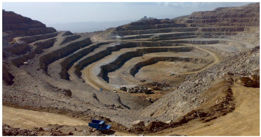
Angouran deposit, NW Iran
Date: 11 October
Guides: Dr. Esmaeil Shabanian
Necessary equipment: Walking shoes, Warm Clothing (jacket, sweater), Raincoat / umbrella, Sunscreen , Sunglasses, Field hat
The Zanjan region in NW Iran, defines the intersection area of the three distinct tectonic provinces of western Alborz,
Central Iran and northwest of Iran. This region is deforming due to the active convergence between Arabia and Eurasia (16 – 26 mm/yr). The particular situation
of the Zanjan region has caused a complex structural pattern of geologically active structures such as the Soltanieh and North Zanjan faults. Despite conspicuous
evidence for geological activities, no historical and instrumental moderate to large earthquakes were reported in the Zanjan region such that the region is
considered as a spatial seismic gap in NW Iran. The tremendous 1990 Manjil – Rudbar earthquake destroyed the northeast margin of the province.
The east-dipping North Zanjan Fault (NZF), with a straight length of ~50 km, is a
structurally complex reverse fault zone at the western end of the Alborz Mountains. This fault zone is constituted by several fault strands oriented in a range of
N40°W to N10°E, with reverse to reverse dextral
kinematics according to their orientation with respect to the present-day compression (N040°E). An average ~60°ENE dip angle was measured for the fault zone.
The NZF cuts across the Quaternary Zanjan depression and passes through the city of Zanjan producing a ~20 m-high reverse fault scarp in the western districts
(Fig. 1). A ~960 m dextral shift is also observed in the Quaternary terrace risers of the Zanjan Rud River due to the penultimate right-lateral kinematics
of the fault. Geomorphic and geological lines of evidence indicate seismogenic behavior of the NZF; detailed structural, geomorphic and paleoseismological studies are
caring out on this fault zone by the Geosciences Department of IASBS.
For further information see:
- Stöcklin, J., & Eftekhar-nezhad, J. (1969). Geol. Surv. Iran (No. D4). Report.
- Sobouti et al. (2007), Report, IASBS, Zanjan, Iran.
- Solaymani Azad, et al. (2011), Tectonophysics, 506(1-4), 73-85.
- Badouzadeh, M. (2018), MSc. Thesis with English abstract, IASBS, Zanjan, Iran.
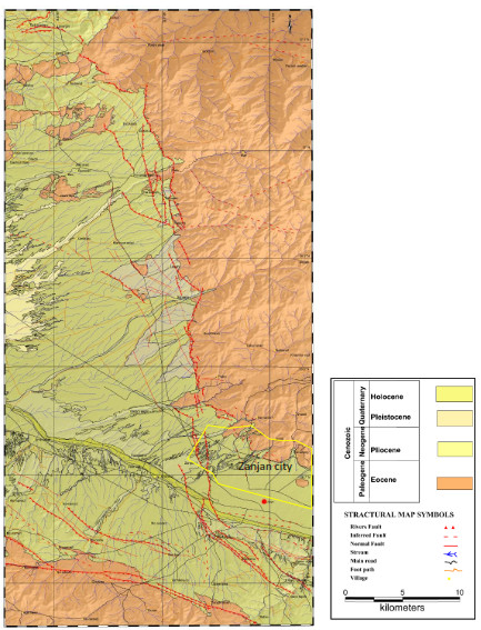
Simplified geological map of the NZF superimposed on the SRTM shaded-relief of the region. Urban areas are marked by yellow polygon.